September 08, 2020 - by Santina Russo
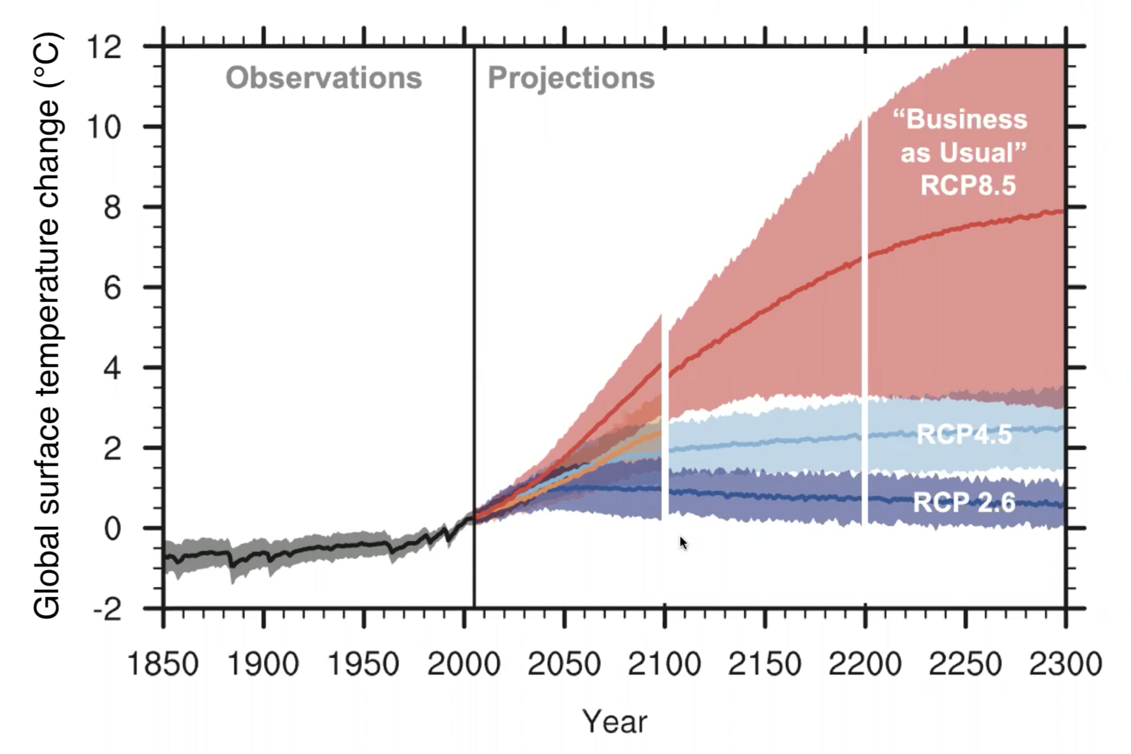
Climate change is already impacting us today: The polar ice caps are melting, temperatures and sea levels are rising, and many extreme weather events like rainstorms and heat waves have grown more severe and more frequent in the last decades. Climate models indicate that these effects will further intensify in the future. However, it is difficult to generate accurate projections since climate models still exhibit a high degree of uncertainty. For instance, one of the most important indicators of global warming, the “equilibrium climate sensitivity” (ECS), which specifies the long term temperature rise (in technical terms: the equilibrium global mean temperature rise) in response to a doubling of atmospheric CO2 concentrations, is currently estimated to lie between an astoundingly broad range of 1.5 to 4.5 degrees Celsius. What is more, this uncertainty range has not decreased in the last 40 years.
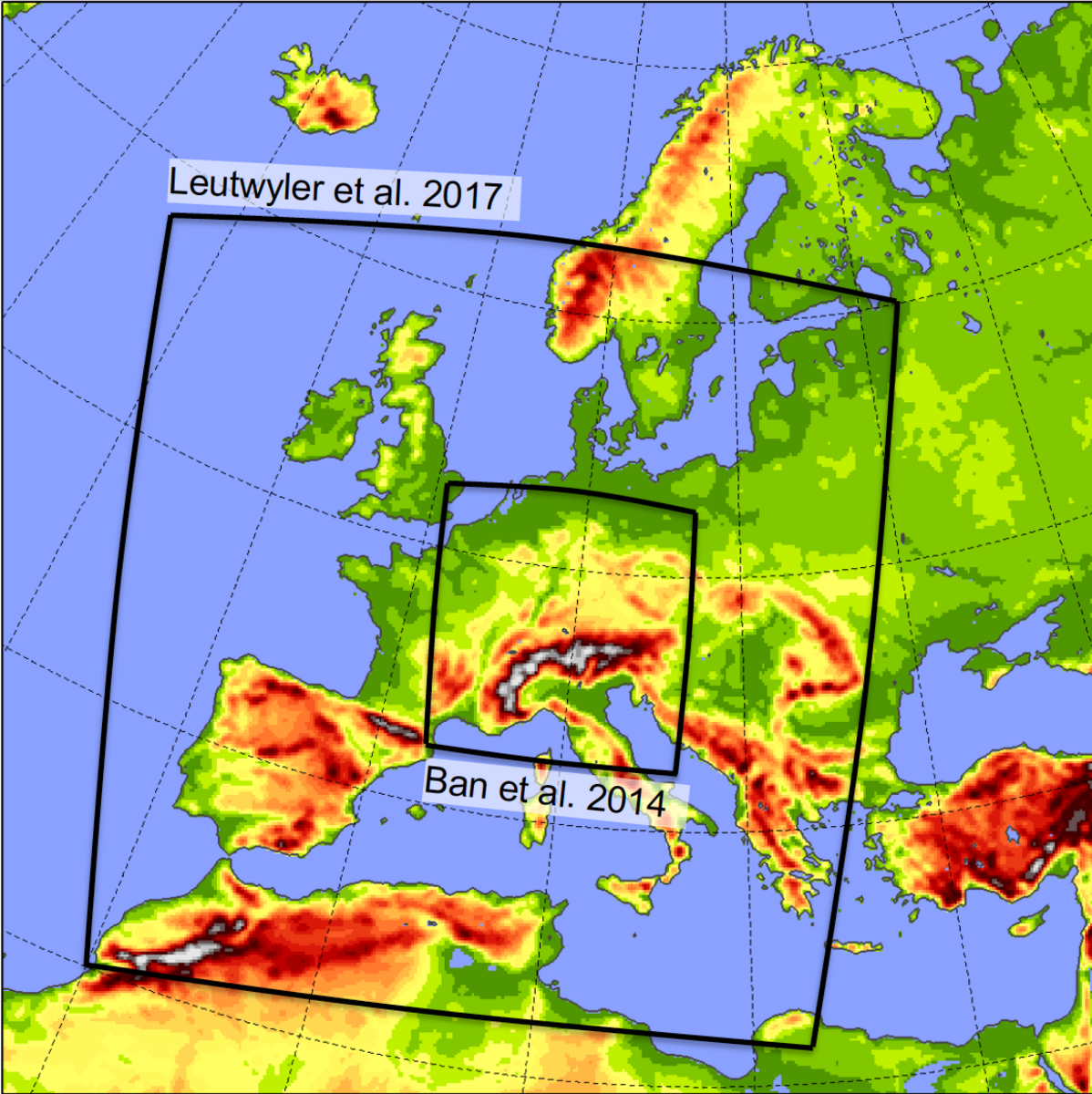
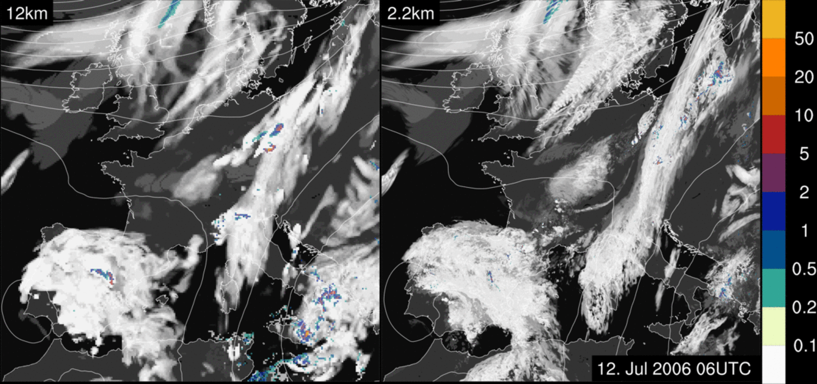
“This is mostly due to the low resolution of current climate models”, explains Christoph Schär, a professor in climate sciences at ETH Zürich. In fact, until very recently, global climate models were considered high resolution if they achieved a horizontal grid spacing of 50 kilometres — meaning the earth’s surface was represented by boxes of 50-by-50 kilometres. Smaller regional climate models, for instance comprising Europe, could be computed at slightly higher resolution with grid sizes down to 12-by-12 kilometres. While these climate models have ascertained that man-made global warming will indeed have severe consequences, their inherent uncertainties hinder accurate projections of sea level rise, regional climate effects and extreme weather events since they have to rely heavily on parametrisations, which means that a significant part of the physics of atmospheric processes has to be approximated.
Kilometre-scale models: a revolution
Recently though, Schär and his team achieved a breakthrough. Using the “Piz Daint” supercomputer at CSCS, the scientists were able to refine the resolution of their regional climate models down to a grid size of only a few kilometres. This high resolution enabled them to reduce uncertainty by explicitly representing a lot more of the relevant physical processes involved in climate and weather — like temperature, wind flows, moisture and pressure — using fluid dynamics calculations with a largely reduced need for approximations. As a result, these models can finally represent processes such as the evolution of clouds and precipitation a lot more accurately than before. That’s why they succeed in tracking local phenomena like thunderstorms and heavy rainfalls even in simulations covering a large geographical area. The new methods will also be beneficial for a range of other phenomena like hurricanes, hail and lightning. “The progress to kilometre-scale resolution represents a real quantum leap in climate modelling”, says Schär.
For their simulations, he and his group employed the widely used COSMO modelling program. The scientists collaborated with the Swiss National Supercomputing Centre (CSCS) and MeteoSwiss — the Swiss Federal Office for Meteorology — who adapted the COSMO code to run on GPUs (graphics processing units) instead of CPUs. “This renders the calculations more efficient, faster and lower cost”, explains Schär. Thus, the simulations can compute one day of real time in 15 minutes of computer time using 140 nodes on the “Piz Daint” supercomputer at CSCS.
More heavy rainfalls in Europe
With this method, Schär and his co-workers were the first scientists to publish climate projections of Europe down to a grid size of 2.2 kilometres. In fact, they computed two distinct simulations, one based in the present (from 1999 to 2008), the other showing future developments (from 2079 to 2088). “In Europe, we are primarily interested in short-term heavy rainfalls, as they frequently occur in summer”, says Schär. For daylong precipitation events, it has been established that the intensity increase will by 7% per degree Celsius of temperature rise. His group’s results have now shown that the same rate also applies to short-term hourly precipitation events. Such heavy precipitation can cause flash floods that damage housing, roads, public amenities and industry sites. “The water infrastructure should therefore be adapted to more frequent and more violent rainfalls”, concludes Schär. Since his high-resolution models can simulate local rainstorms, they can help decision-makers to prepare.
Simultaneously though, the overall precipitation amounts are decreasing. Especially in the Mediterranean area, droughts will impact the soils and how well they can absorb sudden heavy precipitation. With high-resolution climate simulations now available and an improved ground water representation recently developed by his group, Schär intends to investigate this relationship more closely.
The power of tropical clouds
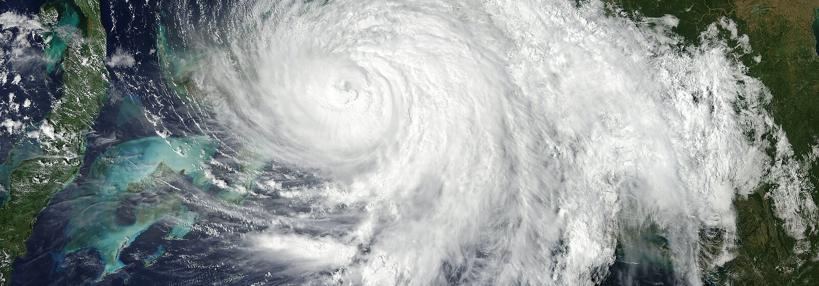
Aside from local droughts, the ongoing changes in the atmospheric water cycle will have an even more significant effect on the global scale: They will affect cloud-cover, which is important because low-level clouds, meaning clouds below 2000 meters, have a cooling effect on global climate due to their ability to reflect sunlight. In fact, Schär’s European simulations from 2079 to 2088 showed a significant reduction of cloud-cover, and he expects a similar result emerging from ongoing simulations over the tropical Atlantic Ocean. These vast areas with tropical clouds have an especially significant influence on global temperature rise.
Again, the jump to kilometre-scale resolution enables more detailed modelling: While only very large cloud patterns are simulated in low-resolution simulations, the high-resolution version quite accurately reproduces the formation, shape and characteristics of clouds. And here, accuracy is particularly important, because inaccurate representations of clouds and their corresponding reflection of sunlight — a property also known as albedo — leads to heavily flawed outcomes.
For instance, a comparison between cloud albedo values of 30% and 28% — a seemingly small difference — translates into a frightening uncertainty range within the global warming indicator ECS: A global albedo of 30% results in an ECS of 3 degrees Celsius in response to a doubling of atmospheric CO2; but an albedo of 28% adds up to a frightening ECS of 8 degrees Celsius. “This means that we must understand even the subtlest changes in tropical cloud-cover and cloud properties in order to generate accurate projections”, says Schär. “With the ability to use kilometre-scale models on much larger areas, we have come a lot closer to reaching this goal.” His group has already run a simulation spanning 40 months over the central Atlantic region reflecting the conditions of the present time, and the team is currently working on a similar simulation that represents future climate scenarios.
Towards a global high-resolution model
At present however, such kilometre-scale models cannot be practically run for the whole planet yet because of their high demand for computing power. Indeed, scientists have already succeeded in performing global high-resolution simulations, but those are limited to a very short period of time of around 10 days — too short a time span to be useful for investigating the climate system. “We still have a long way to go”, says Schär. He intends to continue in his effort to increase the area and time that can be modelled at kilometre-scale in order to one day create a global high-resolution climate simulation.
PRACE allocation:
Project title: Convection-resolving Climate on GPUs (gpuCLIMATE)
Research field: Earth System Sciences
The resources awarded were:
14th call: 89 million core hours on Piz Daint CSCS (Switzerland)
18th call: 95.2 million core hours on Piz Daint CSCS (Switzerland)
References:
- Schär C., Kilometer-scale climate models: Prospects and challenges, BAMS (2019)
- Leutwyler D. and Schär C., Barotropic Instability of a Cyclone Core at Kilometer-Scale Resolution, JAMES (2019)
- Hentgen L., Ban N., Kröner, N., Leutwyler D. and Schär C., Clouds in Convection‐Resolving Climate Simulations Over Europe, JGR Atmospheres (2019)
- Schlemmer L., Schär C., Lüthi D. and Strebel L., A Groundwater and Runoff Formulation for Weather and Climate Models, JAMES (2018)
- Leutwyler D., Lüthi D., Ban N., Fuhrer O. and Schär C., Evaluation of the convection‐resolving climate modeling approach on continental scales, JGR Atmospheres (2017)